
CalTopo: Backcountry Mapping
1.13.3 by Topo Maps, Offline Maps & More (0 Reviews) September 26, 2024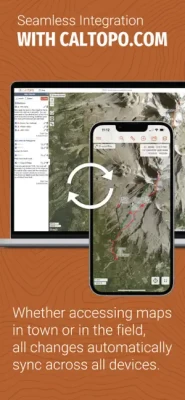
Latest Version
Version
1.13.3
1.13.3
Update
September 26, 2024
September 26, 2024
Developer
Topo Maps, Offline Maps & More
Topo Maps, Offline Maps & More
Categories
Maps & GPS
Maps & GPS
Platforms
iOS
iOS
File Size
125.8 MB
125.8 MB
Downloads
0
0
License
Free
Free
Report
Report a Problem
Report a Problem
More About CalTopo: Backcountry Mapping
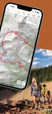
Take the best mapping app with you wherever you go with the CalTopo app for iOS. Trusted by professional mountain guides, avalanche educators, and search and rescue teams, CalTopo has all the features you need to plan your next off-grid pursuit. Seamless integration between CalTopo online and your mobile device allows you to access and update your maps no matter where you are. Any changes you make will automatically sync across all devices, making exporting and importing your latest map a thing of the past.
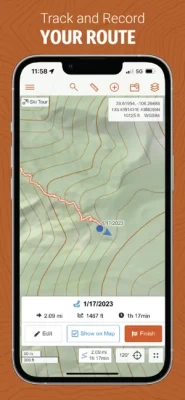
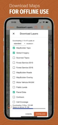
The CalTopo app allows you to easily take your planning and navigation to the next level. Real time decision making in backcountry terrain is made easy with the ability to download maps and layers like slope angle shading to your device for offline use. Plan for conditions on your route with sun exposure, wind, precipitation and avalanche forecasts. View and track your location on the map using GPS, even if you are offline. Share maps with your teams or travel partners to plan collaboratively, and to ensure everyone has the necessary data. Monitor real time updates from the field, like your friends progress on a long outing with live tracking on shared maps.
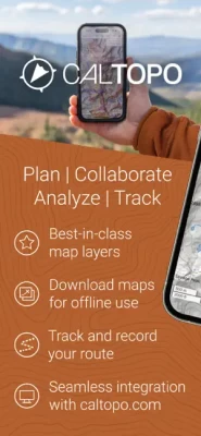
Plan and navigate your next adventure with the CalTopo App today!
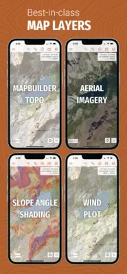
Map layers include:
• MapBuilder Topo, Hybrid and Overlay
• Forest Service Maps
• Scanned Topos
• Global Imagery
• Shaded Relief
• Slope Angle Shading (including high resolution elevation data where available)
• Parcel data
• Public Lands
• Weekly Satellite Imagery
• NAIP Satellite Imagery
• Sun Exposure
• Marine Charts
• Weather Forecasting (including wind, precipitation, and temperatures)
• Snow and Water Gauge Data
• Fire History/Activity
• And many more
Support and Feature Requests:
Email us at help@caltopo.com.
Plan and navigate your next adventure with the CalTopo App today!
Map layers include:
• MapBuilder Topo, Hybrid and Overlay
• Forest Service Maps
• Scanned Topos
• Global Imagery
• Shaded Relief
• Slope Angle Shading (including high resolution elevation data where available)
• Parcel data
• Public Lands
• Weekly Satellite Imagery
• NAIP Satellite Imagery
• Sun Exposure
• Marine Charts
• Weather Forecasting (including wind, precipitation, and temperatures)
• Snow and Water Gauge Data
• Fire History/Activity
• And many more
Support and Feature Requests:
Email us at help@caltopo.com.
Rate the App
Add Comment & Review
User Reviews
Based on 0 reviews
No reviews added yet.
Comments will not be approved to be posted if they are SPAM, abusive, off-topic, use profanity, contain a personal attack, or promote hate of any kind.