
AR AlpineGuide
4.56.1 by Noriyoshi Tsunashima (0 Reviews) September 28, 2024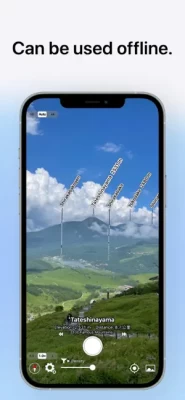


Latest Version
Version
4.56.1
4.56.1
Update
September 28, 2024
September 28, 2024
Developer
Noriyoshi Tsunashima
Noriyoshi Tsunashima
Categories
Maps & GPS
Maps & GPS
Platforms
iOS
iOS
File Size
116.4 MB
116.4 MB
Downloads
0
0
License
Free
Free
Report
Report a Problem
Report a Problem
More About AR AlpineGuide
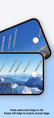
Point your iOS device at the mountain and you'll see the name, altitude, and distance of the mountaintop.You can identify the names of all the mountain peaks in the 360-degree panoramic AR view.All features are free to use.
Over 1 million downloads total for all platforms!
Features
- It has data from nearly one million peaks around the world.
- It uses three-dimensional coordinates and a gyroscope to display the name at the peak, even if you tilt the camera. The display makes it easy to check.
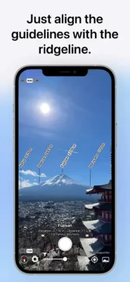
- The three-dimensional terrain is displayed semi-transparently, so it is easy to compare it with the actual shape of the mountain and check the location of the peak.
- When you point your iOS device downward, the view switches to a 3D view looking down from the sky.
- You can check the names of the terrain and mountains that can be seen from any location specified on the map.
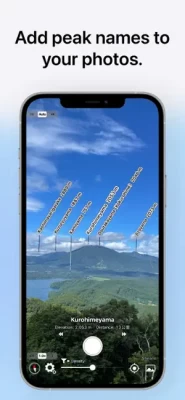
- You can take a photo with the name of the peak and share it via SNS or email.
- Swiping the AR display up, down, left, or right allows you to adjust the position of the peak name display.
- It is possible to adjust the position of the peak name display after the picture is taken.
- You can import photos taken with another app and add the peak name.
- All the features are free!
※ If the direction is not correct (e.g. it always shows North), if your iOS device has a cover on it If there is a sensor in the case, please remove it. The metal or magnet on the cover may interfere with the sensor and cause it to malfunction.
Terms of Service
https://www.apple.com/legal/internet-services/itunes/dev/stdeula/
Features
- It has data from nearly one million peaks around the world.
- It uses three-dimensional coordinates and a gyroscope to display the name at the peak, even if you tilt the camera. The display makes it easy to check.
- The three-dimensional terrain is displayed semi-transparently, so it is easy to compare it with the actual shape of the mountain and check the location of the peak.
- When you point your iOS device downward, the view switches to a 3D view looking down from the sky.
- You can check the names of the terrain and mountains that can be seen from any location specified on the map.
- You can take a photo with the name of the peak and share it via SNS or email.
- Swiping the AR display up, down, left, or right allows you to adjust the position of the peak name display.
- It is possible to adjust the position of the peak name display after the picture is taken.
- You can import photos taken with another app and add the peak name.
- All the features are free!
※ If the direction is not correct (e.g. it always shows North), if your iOS device has a cover on it If there is a sensor in the case, please remove it. The metal or magnet on the cover may interfere with the sensor and cause it to malfunction.
Terms of Service
https://www.apple.com/legal/internet-services/itunes/dev/stdeula/
Rate the App
Add Comment & Review
User Reviews
Based on 0 reviews
No reviews added yet.
Comments will not be approved to be posted if they are SPAM, abusive, off-topic, use profanity, contain a personal attack, or promote hate of any kind.