
UAV Monitoring
1.0.2 by Inspection app (0 Reviews) September 12, 2024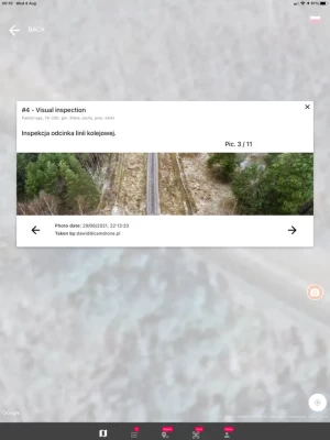
Latest Version
Version
1.0.2
1.0.2
Update
September 12, 2024
September 12, 2024
Developer
Inspection app
Inspection app
Categories
Photo & Video
Photo & Video
Platforms
iOS
iOS
File Size
68.8 MB
68.8 MB
Downloads
0
0
License
Free
Free
Report
Report a Problem
Report a Problem
More About UAV Monitoring
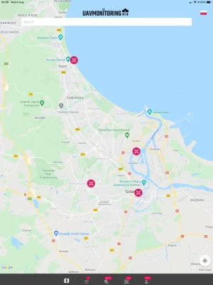
UavMonitoring is an application for the management and analysis of environmental damage reports and related visual inspections. It allows for quick analysis of data collected by unmanned aerial vehicles, ground vehicles and IoT devices, which are visualized and archived in the application.
The application is dedicated to:
- Local government units where employees can easily and quickly locate the places where the regulations have been violated, create reports and order appropriate inspections using drones.
- Air inspection companies. UavMonitoring facilitates the management and processing of collected data.
Application functionalities:
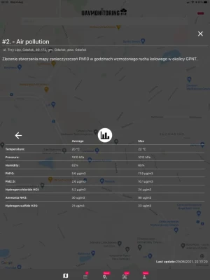
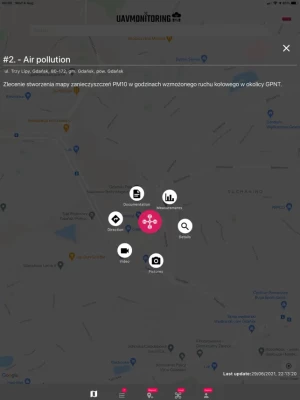
- An internal system dedicated to companies, cities and municipal offices to manage reports related to inspections of areas or facilities, air pollution, illegal landfills, water pollution and other reports requiring the reaction of employees of the company and local authorities and affiliates, i.e. municipal police, police , security services, etc.
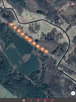
- A public or dedicated interface based on a map, on which users (employees) are able to embed a report in the form of text and photo / video material from the scene (from the ground and from the air, i.e. a drone or a mobile device - tablet / phone) along with with GPS location.
- Air and ground inspection data processing and visualization system.
- Options for managing tickets, determining the priority and status of tickets.
- Creation of reports and documentation related to applications.
- Option to order a service from UAVmonitoring for inspection of the notification, including the provision of documentation regarding the event - photos, data on concentrations of hazardous substances in the air / dust, thermovision data.
- Possibility to make publicly selected inspection data available in the mobile application.
- Presentation and archiving of collected data in a visual form (charts, maps, 3D visualizations) and in the form of XLS or PDF reports.
- Local government units where employees can easily and quickly locate the places where the regulations have been violated, create reports and order appropriate inspections using drones.
- Air inspection companies. UavMonitoring facilitates the management and processing of collected data.
Application functionalities:
- An internal system dedicated to companies, cities and municipal offices to manage reports related to inspections of areas or facilities, air pollution, illegal landfills, water pollution and other reports requiring the reaction of employees of the company and local authorities and affiliates, i.e. municipal police, police , security services, etc.
- A public or dedicated interface based on a map, on which users (employees) are able to embed a report in the form of text and photo / video material from the scene (from the ground and from the air, i.e. a drone or a mobile device - tablet / phone) along with with GPS location.
- Air and ground inspection data processing and visualization system.
- Options for managing tickets, determining the priority and status of tickets.
- Creation of reports and documentation related to applications.
- Option to order a service from UAVmonitoring for inspection of the notification, including the provision of documentation regarding the event - photos, data on concentrations of hazardous substances in the air / dust, thermovision data.
- Possibility to make publicly selected inspection data available in the mobile application.
- Presentation and archiving of collected data in a visual form (charts, maps, 3D visualizations) and in the form of XLS or PDF reports.
Rate the App
Add Comment & Review
User Reviews
Based on 0 reviews
No reviews added yet.
Comments will not be approved to be posted if they are SPAM, abusive, off-topic, use profanity, contain a personal attack, or promote hate of any kind.