
Seaside Buoy
1.8.3 by Live ocean buoy data worldwide (0 Reviews) December 13, 2023
Latest Version
Version
1.8.3
1.8.3
Update
December 13, 2023
December 13, 2023
Developer
Live ocean buoy data worldwide
Live ocean buoy data worldwide
Categories
Weather
Weather
Platforms
iOS
iOS
File Size
24.2 MB
24.2 MB
Downloads
0
0
License
Free
Free
Report
Report a Problem
Report a Problem
More About Seaside Buoy
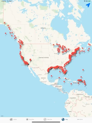
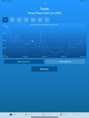
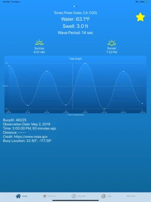
Live scientific readings from ocean buoys around the world. Data is provided by the National Data Buoy Center of NOAA and other public scientific organizations. Most buoys report water temperature and swell height, but some have more information available than others. Automatically select the closest buoy, choose one from the map, or choose from the list. Build a list of favorites for quick access to key buoys. With your device's location function turned on, bearing and distance to the buoy is calculated and displayed. This app is lightweight, easy-to-use, and requires virtually no data usage.
Currently, buoys are included from the following locations:
US Pacific: Washington to California
US Atlantic: Main to Florida
Alaska
Hawaii
US Virgin Islands
Puerto Rico
US/Canada Great Lakes
Caribbean
Gulf of Mexico
United Kingdom
Ireland
Spain
Portugal
Italy
Australia
Chile
US Pacific: Washington to California
US Atlantic: Main to Florida
Alaska
Hawaii
US Virgin Islands
Puerto Rico
US/Canada Great Lakes
Caribbean
Gulf of Mexico
United Kingdom
Ireland
Spain
Portugal
Italy
Australia
Chile
Rate the App
Add Comment & Review
User Reviews
Based on 0 reviews
No reviews added yet.
Comments will not be approved to be posted if they are SPAM, abusive, off-topic, use profanity, contain a personal attack, or promote hate of any kind.