
River Levels & Flows
1.1.12 by USGS River Levels & Flows (0 Reviews) January 07, 2024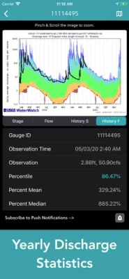
Latest Version
Version
1.1.12
1.1.12
Update
January 07, 2024
January 07, 2024
Developer
USGS River Levels & Flows
USGS River Levels & Flows
Categories
Weather
Weather
Platforms
iOS
iOS
File Size
25.2 MB
25.2 MB
Downloads
0
0
License
$2.99
$2.99
Report
Report a Problem
Report a Problem
More About River Levels & Flows
Main Features Include: + USGS / AHPS River Levels & Flows + Gauge Flood Status Push Notifications + Weather Prediction Center Charts
Interactive USGS / AHPS Gauge Map
The USGS maintains a national network of stream gauges that provide hydrological observations. In addition, AHPS collects real-time water level information from other federal, state, and local stream gauge networks.
USGS / AHPS Hydrological Data Includes:
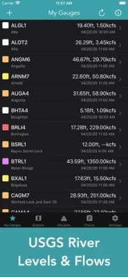
+ Water Level & Flow Observations
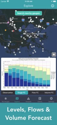
+ Gauge Levels, Flows & Volume Forecast
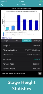
+ Gauge History & Statistics
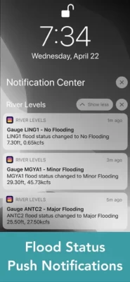
+ Flood Status Push Notifications
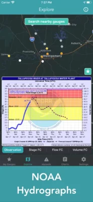
Weather Prediction Center Charts
+ Significant River Flood Outlook
+ Quantitative Precipitation Forecasts
+ Excessive Rainfall Outlook
+ U.S Hazards Outlook
+ Risk of Heavy Precipitation
Enjoy!
The USGS maintains a national network of stream gauges that provide hydrological observations. In addition, AHPS collects real-time water level information from other federal, state, and local stream gauge networks.
USGS / AHPS Hydrological Data Includes:
+ Water Level & Flow Observations
+ Gauge Levels, Flows & Volume Forecast
+ Gauge History & Statistics
+ Flood Status Push Notifications
Weather Prediction Center Charts
+ Significant River Flood Outlook
+ Quantitative Precipitation Forecasts
+ Excessive Rainfall Outlook
+ U.S Hazards Outlook
+ Risk of Heavy Precipitation
Enjoy!
Rate the App
Add Comment & Review
User Reviews
Based on 0 reviews
No reviews added yet.
Comments will not be approved to be posted if they are SPAM, abusive, off-topic, use profanity, contain a personal attack, or promote hate of any kind.