RipCharts
2.7.121 by RipCharts (0 Reviews) September 11, 2024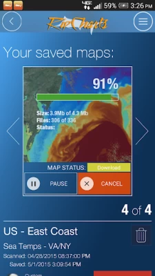
Latest Version
Version
2.7.121
2.7.121
Update
September 11, 2024
September 11, 2024
Developer
RipCharts
RipCharts
Categories
Sports
Sports
Platforms
Android
Android
Downloads
0
0
License
Free
Free
Package Name
com.ripcharts.android
com.ripcharts.android
Report
Report a Problem
Report a Problem
More About RipCharts
Welcome to RipCharts - The industry leader in satellite fishing maps. This app is free to download for existing RipCharts Premium subscribers. If you are new to RipCharts, then we allow you to purchase a new RipCharts subscription via an In-App-Purchase. Please contact us if you have questions or would like a complementary demo. (http://www.ripcharts.com)
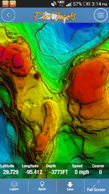
The RipCharts mobile app is a powerful tool that enables offshore fishermen to evaluate recent satellite imagery in order to determine favorable fishing conditions. Search for, view, and download maps of near-realtime satellite imagery onto your device to take with you offshore.
View the latest imagery datasets:
- Raw SST orbit scans
- Composite SST (1day,3day)
- Multi-Res/Cloud Free SST
- Sub-surface SST (0m, -25m, -50m, -100m)
- 5 day SST forecast models
- Chlorophyll
- Chlorophyll/Cloud mashups
- Chlorophyll composites
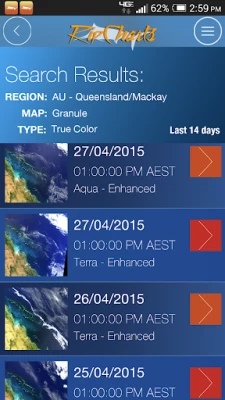
- True Color
- Altimetry
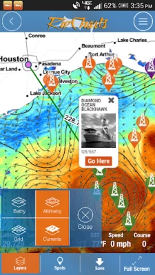
- Currents
- Salinity
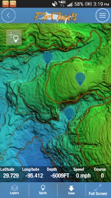
- Bathymetry
Map Features:
Use the multi-touch map to zoom, pan, view waypoints, and overlay additional data layers to gain insight into where the most favorable fishing zones are located.
Mapping Tools:
- Measure distances and headings between points
- Dynamically customize temp/color ranges on SST maps to identify subtle breaks <-- powerful feature!
- Overlay bathymetry, altimetry, currents, and Loran layers
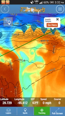
- Tap the map to receive point information (lat, lon, depth, SST)
- Popular waypoints and fishing hotspots come pre-loaded
- Manage your personal waypoints (add,edit,delete)
- Save imagery to your device for offline/offshore use
- Show your position and navigate on saved imagery using GPS satellites
- "Go Here" navigation with bearing, ETA, and speed displays
- Floater oil rig positions updated twice daily (Gulf of Mexico only)
View the latest imagery datasets:
- Raw SST orbit scans
- Composite SST (1day,3day)
- Multi-Res/Cloud Free SST
- Sub-surface SST (0m, -25m, -50m, -100m)
- 5 day SST forecast models
- Chlorophyll
- Chlorophyll/Cloud mashups
- Chlorophyll composites
- True Color
- Altimetry
- Currents
- Salinity
- Bathymetry
Map Features:
Use the multi-touch map to zoom, pan, view waypoints, and overlay additional data layers to gain insight into where the most favorable fishing zones are located.
Mapping Tools:
- Measure distances and headings between points
- Dynamically customize temp/color ranges on SST maps to identify subtle breaks <-- powerful feature!
- Overlay bathymetry, altimetry, currents, and Loran layers
- Tap the map to receive point information (lat, lon, depth, SST)
- Popular waypoints and fishing hotspots come pre-loaded
- Manage your personal waypoints (add,edit,delete)
- Save imagery to your device for offline/offshore use
- Show your position and navigate on saved imagery using GPS satellites
- "Go Here" navigation with bearing, ETA, and speed displays
- Floater oil rig positions updated twice daily (Gulf of Mexico only)
Rate the App
Add Comment & Review
User Reviews
Based on 0 reviews
No reviews added yet.
Comments will not be approved to be posted if they are SPAM, abusive, off-topic, use profanity, contain a personal attack, or promote hate of any kind.