NZ Topo50 Offline - South
by Right Place Resources (0 Reviews) September 15, 2024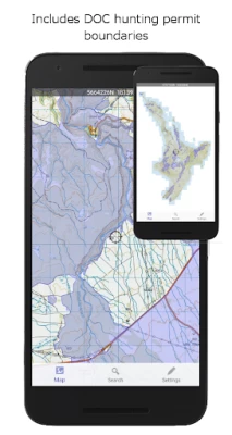
Latest Version
Update
September 15, 2024
September 15, 2024
Developer
Right Place Resources
Right Place Resources
Categories
Maps & GPS
Maps & GPS
Platforms
Android
Android
Downloads
0
0
License
$3.49
$3.49
Package Name
net.sqrl.nztopo50s
net.sqrl.nztopo50s
Report
Report a Problem
Report a Problem
More About NZ Topo50 Offline - South
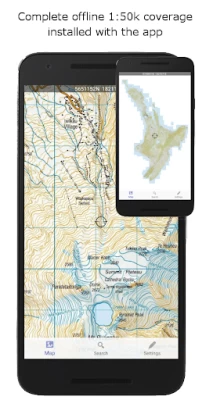
Complete 1:50k offline topographic map coverage using the LINZ NZTopo50 series maps. The maps are included fully with the install. No additional downloads, no account signup, no missing tiles, no added fees, just seamless offline pan and zoom across the whole South Island.
Ideal for back country navigation without cell phone access. Popular with trampers, walkers, bikers, runners, hunters, search and rescue, Te Araroa walkers.
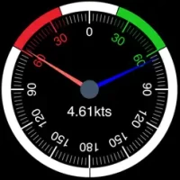
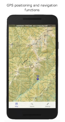
Navigation functions includes GPS positioning, track logging, user waypoints, orientation (compass), altitude and speed display, distance and bearing to points on the map, route creation, route following. Search for and zoom to named places and features on the map. Tracks and waypoints can be imported, exported, and shared in kml or gpx format.
Overlays including DOC open permit hunting boundaries, Te Araroa tracks, and other data is included.
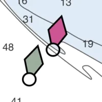
This app is built from the ground up to use the NZ national map grid, not the global average WGS84 datum commonly used which distorts the map. This is easy to spot. A true NZ grid will give you perfectly parallel gridlines when the LINZ map is projected onto it.
No internet or cellular phone connection is needed for full use of all the maps and navigation functions.
The storage space required for this app is reasonably large. Ensure you have sufficient space available.
Made in NZ.
Navigation functions includes GPS positioning, track logging, user waypoints, orientation (compass), altitude and speed display, distance and bearing to points on the map, route creation, route following. Search for and zoom to named places and features on the map. Tracks and waypoints can be imported, exported, and shared in kml or gpx format.
Overlays including DOC open permit hunting boundaries, Te Araroa tracks, and other data is included.
This app is built from the ground up to use the NZ national map grid, not the global average WGS84 datum commonly used which distorts the map. This is easy to spot. A true NZ grid will give you perfectly parallel gridlines when the LINZ map is projected onto it.
No internet or cellular phone connection is needed for full use of all the maps and navigation functions.
The storage space required for this app is reasonably large. Ensure you have sufficient space available.
Made in NZ.
Rate the App
Add Comment & Review
User Reviews
Based on 0 reviews
No reviews added yet.
Comments will not be approved to be posted if they are SPAM, abusive, off-topic, use profanity, contain a personal attack, or promote hate of any kind.