
My Altitude and Elevation
1.0 by Bhavik Savaliya (0 Reviews) March 30, 2024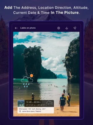
Latest Version
Version
1.0
1.0
Update
March 30, 2024
March 30, 2024
Developer
Bhavik Savaliya
Bhavik Savaliya
Categories
Weather
Weather
Platforms
iOS
iOS
File Size
74 MB
74 MB
Downloads
0
0
License
Free
Free
Report
Report a Problem
Report a Problem
More About My Altitude and Elevation
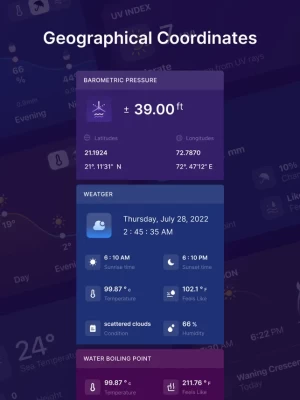
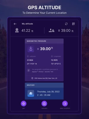
This app uses GPS signals to determine your current location, showing your latitude, longitude and altitude (height from sea level) barometric pressure and boiling point.
My Altitude and Elevation uses web services to get your precise surface elevation based on your current location. This is far more accurate than the elevation data provided by your device. But there's so much more you can do with My Altitude and Elevation. Try it and see!
You can select from the best sources of elevation data, including:
1. Location based altitude from NASA's Shuttle Radar Topography Mission.
2. Satellite based altitude (GPS altitude) corrected to height above mean sea level (AMSL).
3. Get actual land survey altitude values for your location from the United States Geologic Survey - available for customers in the contiguous United States, southern Canada and Mexico.
4. Devices equipped with a barometer sensor can also obtain pressure altitude which is converted to elevation above sea level. For the most precise readings, calibrate the pressure altitude.
Barometer and Altimeter features:
- accurate height measurement above sea level (from GPS and other sensors),
- accurate measurement of barometric pressure (if the device is equipped in pressure sensor and check data available online)
- GPS coordinates, name of location, country
- information and current weather data from your local weather station (if available).
- outside temperature,
- wind speed,
- visibility,
- humidity, hygrometer (if device is equipped with appropriate sensors).
App Features:
- Elevation from see level in meter (metric) or feet (imperial)
- Change between metric and imperial systems by tapping on reported elevation
- Current location coordinates including latitude and longitude
- Barometric pressure in various units extracted from device sensor or calculated from altitude
- Water boiling point at your current location
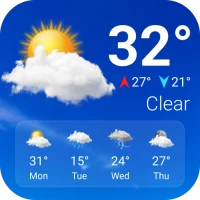
- Current weather information including temperature, condition, humidity, wind speed and wind bearing
- World Altitude, get approximate altitude (elevation from see level) of any location in the world
- Save altitude data for reference
- Take a picture and watermark it with elevation information and share
You can select from the best sources of elevation data, including:
1. Location based altitude from NASA's Shuttle Radar Topography Mission.
2. Satellite based altitude (GPS altitude) corrected to height above mean sea level (AMSL).
3. Get actual land survey altitude values for your location from the United States Geologic Survey - available for customers in the contiguous United States, southern Canada and Mexico.
4. Devices equipped with a barometer sensor can also obtain pressure altitude which is converted to elevation above sea level. For the most precise readings, calibrate the pressure altitude.
Barometer and Altimeter features:
- accurate height measurement above sea level (from GPS and other sensors),
- accurate measurement of barometric pressure (if the device is equipped in pressure sensor and check data available online)
- GPS coordinates, name of location, country
- information and current weather data from your local weather station (if available).
- outside temperature,
- wind speed,
- visibility,
- humidity, hygrometer (if device is equipped with appropriate sensors).
App Features:
- Elevation from see level in meter (metric) or feet (imperial)
- Change between metric and imperial systems by tapping on reported elevation
- Current location coordinates including latitude and longitude
- Barometric pressure in various units extracted from device sensor or calculated from altitude
- Water boiling point at your current location
- Current weather information including temperature, condition, humidity, wind speed and wind bearing
- World Altitude, get approximate altitude (elevation from see level) of any location in the world
- Save altitude data for reference
- Take a picture and watermark it with elevation information and share
Rate the App
Add Comment & Review
User Reviews
Based on 0 reviews
No reviews added yet.
Comments will not be approved to be posted if they are SPAM, abusive, off-topic, use profanity, contain a personal attack, or promote hate of any kind.