
Metar-Taf
2.5.0 by Visual decoder METAR & TAF (0 Reviews) December 15, 2023

Latest Version
Version
2.5.0
2.5.0
Update
December 15, 2023
December 15, 2023
Developer
Visual decoder METAR & TAF
Visual decoder METAR & TAF
Categories
Weather
Weather
Platforms
iOS
iOS
File Size
20.4 MB
20.4 MB
Downloads
0
0
License
$4.99
$4.99
Report
Report a Problem
Report a Problem
More About Metar-Taf
- SDK upgrade- Added hint about sorting airports in the favorites list
Visualized METAR and TAF weather information for all airports in the world. Concise summary of everything you need to know about today's aviation weather.
METAR features:
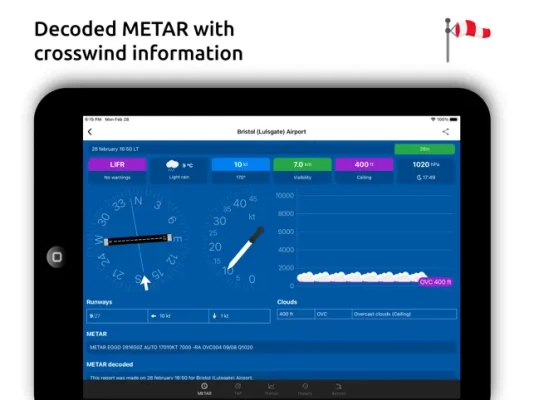
- Visualized in easy to understand and colourful metrics
- Weather symbols for significant weather and clouds, like in a non-aviation weather report
- Crosswind calculations, by combining METAR and runway information
- Flight rules category: VFR, MVFR, IFR, LIFR
- Read out by text-to-speech available, listen to a decoded METAR while doing other things
TAF features:
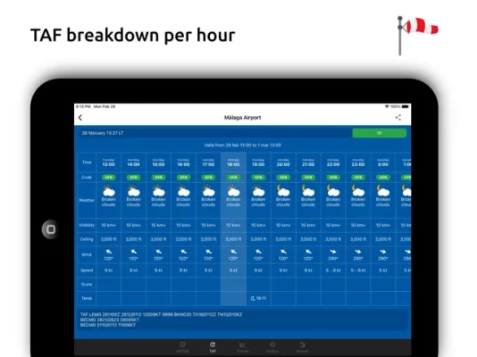
- TAF broken down and displayed per hour in a table
- Show sunrise/sunset, minimum and maximum temperature
NOTAM features:
- Timeline with NOTAMs sorted by issue date
- Coordinates from NOTAMs plotted on map
Keeping track:
- Add your favorite stations to the list, see their weather at a glance
- Get observations near your location
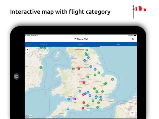
- Find stations in the interactive map with weather codes
- Search airports by ICAO code or name
History:
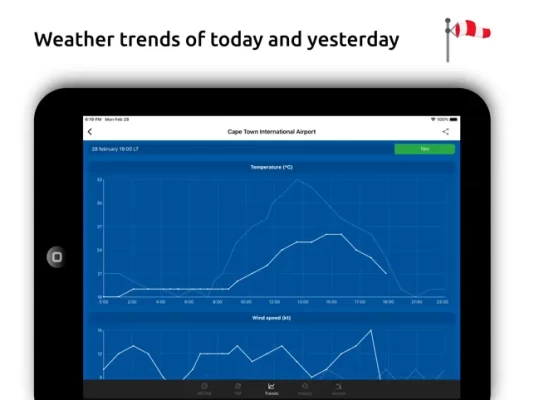
- Graphs with weather trends today and yesterday: temperature, visibility, wind speed, QNH
- METAR history for the last hours and link to more on the website
Airport information:
- See information about the airports, like runway directions, elevation, location
- If the airport doesn't report a METAR, the nearest station used for calculations
Calculations:
- All units are customizable units: speed (knots, km/h, m/s, mph), altitude (meters/feet), visibility (kilometers/miles), temperature (Celcius/Fahrenheit) and air pressure (Hectopascal, Inch Hg)
- Times are converted to the local time for each airport
- Sunrise and sunset are calculated based on the airports latitude/longitude
General:
- METAR, TAF and airport data are automatically saved for offline use
- Available in 6 languages: English, Dutch, Spanish, Portuguese, German and French
METAR features:
- Visualized in easy to understand and colourful metrics
- Weather symbols for significant weather and clouds, like in a non-aviation weather report
- Crosswind calculations, by combining METAR and runway information
- Flight rules category: VFR, MVFR, IFR, LIFR
- Read out by text-to-speech available, listen to a decoded METAR while doing other things
TAF features:
- TAF broken down and displayed per hour in a table
- Show sunrise/sunset, minimum and maximum temperature
NOTAM features:
- Timeline with NOTAMs sorted by issue date
- Coordinates from NOTAMs plotted on map
Keeping track:
- Add your favorite stations to the list, see their weather at a glance
- Get observations near your location
- Find stations in the interactive map with weather codes
- Search airports by ICAO code or name
History:
- Graphs with weather trends today and yesterday: temperature, visibility, wind speed, QNH
- METAR history for the last hours and link to more on the website
Airport information:
- See information about the airports, like runway directions, elevation, location
- If the airport doesn't report a METAR, the nearest station used for calculations
Calculations:
- All units are customizable units: speed (knots, km/h, m/s, mph), altitude (meters/feet), visibility (kilometers/miles), temperature (Celcius/Fahrenheit) and air pressure (Hectopascal, Inch Hg)
- Times are converted to the local time for each airport
- Sunrise and sunset are calculated based on the airports latitude/longitude
General:
- METAR, TAF and airport data are automatically saved for offline use
- Available in 6 languages: English, Dutch, Spanish, Portuguese, German and French
Rate the App
Add Comment & Review
User Reviews
Based on 0 reviews
No reviews added yet.
Comments will not be approved to be posted if they are SPAM, abusive, off-topic, use profanity, contain a personal attack, or promote hate of any kind.