
Marine Weather Pro| SailGrib
2.3 by SailGrib (0 Reviews) January 22, 2024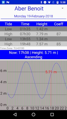
Latest Version
Version
2.3
2.3
Update
January 22, 2024
January 22, 2024
Developer
SailGrib
SailGrib
Categories
Weather
Weather
Platforms
Android
Android
Downloads
0
0
License
$19.99
$19.99
Package Name
com.sailgrib.paid
com.sailgrib.paid
Report
Report a Problem
Report a Problem
More About Marine Weather Pro| SailGrib
YACHTING WORLD - "IMPRESSIVE" - July 2014
Designed for Iridium GO! and Approved by Iridium.
SaiGrib is a weather and tides forecast app designed for the sailing community, cruisers and raceers, worlwide.
Get all the major models of weather forecast from many different sources in one easy to use app.
Weather data are downloaded as grib files while tides are calculated locally on your device.
Features
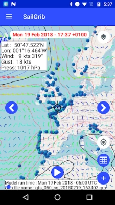
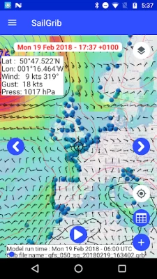
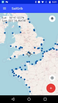
- pan and zoom the map to choose your region
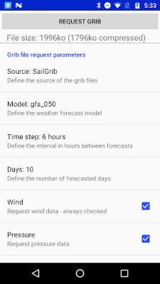
- download data using the best Grib files providers : SailGrib, Great Circle, GMN, OpenWRF, SailDocs...
- specify the parameters(wind, pressure...) to your needs
- request can be adjusted to match a maximum file size
- can be used at sea with a satellite phone or the Iridium Go
- offlline maps capability combined with satellite mail allows usage at sea.
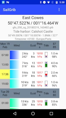
With SailGrib, you can download and view the following data:
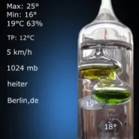
- Wind (10m above sea level)
- Pressure (reduced to mean sea level)
- Precipitation (accumulated over 6 hours)
- Total cloud cover
- Air Temperature ( 2m above ground)
- Wave (significant wave height, mean wave direction and period)
- CAPE
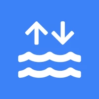
- Tidal or oceanic currents
With SailGrib, you can specify the following parameters for your grib file request:
- grib provider : SailGrib, Great Circle, SailDocs, Open WRF, MeteoConsult, GMN, Mercator Ocean for oceanic and coastal currents ....
- request method : direct download (SailGrib, Great Circle, MeteoConsult, GMN) or email (SailDocs, GMN or Great Circle)
- grid resolution: from very high resolution to 2.5°
- time step between forecasts :from 1 hour to 12 hours depending on models
- number of days for the forecast: from 1 to 14 depending on model
- maximum file size. SailGrib estimates the size of the grib file you request and adjust the grid resolution and the time step to make sure your file will size be lower than your set limit.
With SailGrib, you can view the following data:
- Windbarbs
- Isobars
- Precipitation maps
- Cloud cover maps
- Temperature maps
- Waves maps and arrows
- CAPE map
- Currents
WARNINGS:
- Tide forecast are not official and are for reference purpose only.
- Grib files are computer-generated forecast files which are sent without review, and are offered on an as-is basis. There is no assurance that the data is accurate or correct. By using these data you agree to these limitations and assume all the responsibility for their use.
DISCLOSURE:
SailGrib uses the JGRIB Java GRIB decoder (jgrib.sourceforge.net) and OpenStreetMap (www.openstreetmap.org)
SaiGrib is a weather and tides forecast app designed for the sailing community, cruisers and raceers, worlwide.
Get all the major models of weather forecast from many different sources in one easy to use app.
Weather data are downloaded as grib files while tides are calculated locally on your device.
Features
- pan and zoom the map to choose your region
- download data using the best Grib files providers : SailGrib, Great Circle, GMN, OpenWRF, SailDocs...
- specify the parameters(wind, pressure...) to your needs
- request can be adjusted to match a maximum file size
- can be used at sea with a satellite phone or the Iridium Go
- offlline maps capability combined with satellite mail allows usage at sea.
With SailGrib, you can download and view the following data:
- Wind (10m above sea level)
- Pressure (reduced to mean sea level)
- Precipitation (accumulated over 6 hours)
- Total cloud cover
- Air Temperature ( 2m above ground)
- Wave (significant wave height, mean wave direction and period)
- CAPE
- Tidal or oceanic currents
With SailGrib, you can specify the following parameters for your grib file request:
- grib provider : SailGrib, Great Circle, SailDocs, Open WRF, MeteoConsult, GMN, Mercator Ocean for oceanic and coastal currents ....
- request method : direct download (SailGrib, Great Circle, MeteoConsult, GMN) or email (SailDocs, GMN or Great Circle)
- grid resolution: from very high resolution to 2.5°
- time step between forecasts :from 1 hour to 12 hours depending on models
- number of days for the forecast: from 1 to 14 depending on model
- maximum file size. SailGrib estimates the size of the grib file you request and adjust the grid resolution and the time step to make sure your file will size be lower than your set limit.
With SailGrib, you can view the following data:
- Windbarbs
- Isobars
- Precipitation maps
- Cloud cover maps
- Temperature maps
- Waves maps and arrows
- CAPE map
- Currents
WARNINGS:
- Tide forecast are not official and are for reference purpose only.
- Grib files are computer-generated forecast files which are sent without review, and are offered on an as-is basis. There is no assurance that the data is accurate or correct. By using these data you agree to these limitations and assume all the responsibility for their use.
DISCLOSURE:
SailGrib uses the JGRIB Java GRIB decoder (jgrib.sourceforge.net) and OpenStreetMap (www.openstreetmap.org)
Rate the App
Add Comment & Review
User Reviews
Based on 0 reviews
No reviews added yet.
Comments will not be approved to be posted if they are SPAM, abusive, off-topic, use profanity, contain a personal attack, or promote hate of any kind.