Hurricane Track+ Storm Tracker
3.3.5 by Weather, Tracker, and Radar (0 Reviews) April 11, 2024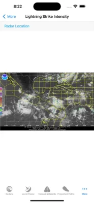
Latest Version
Version
3.3.5
3.3.5
Update
April 11, 2024
April 11, 2024
Developer
Weather, Tracker, and Radar
Weather, Tracker, and Radar
Categories
Weather
Weather
Platforms
iOS
iOS
File Size
27.6 MB
27.6 MB
Downloads
0
0
License
$2.99
$2.99
Report
Report a Problem
Report a Problem
More About Hurricane Track+ Storm Tracker
*This is the Ad-Free version of Hurricane Track*
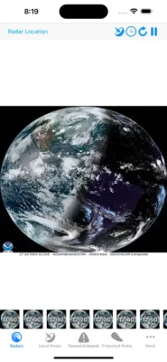
Hurricane Track 3.0 is the most advanced, modern, and easiest to use Hurricane Tracking and Radar application! Hurricane Track 3.0 features incredible new features such as 18 World Radars featuring the newly launched GOES-16 Satellite, a new customizable dynamic Local Radar using NEXRAD "next-generation radar" technology, Forecast and Hazard warnings, future projected tropical cyclone paths, Lightning Intensity Radars, Sea Temperatures, Cloud Formations that can potentially turn into tropical cyclones, Maps, an interactive 3D Earth, detailed tropical storm information and discussion, and much much more! Hurricane Track 3.0 brings the most advanced hurricane tracking technology to your fingertips!
Innovative Features!
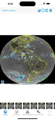
- 300+ World Radars: 18 Radar Locations around the globe with 17 Radars per Location
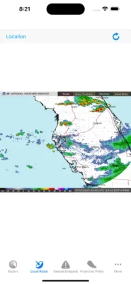
- Customizable Advanced Local Radar using NEXRAD technology (U.S. only)
- Projected Tropical Storm paths: Future tropical storm paths for the next five days
- Forecast and Hazards give you detailed forecasts for different periods of the day, and hazards that you should look out for (Tornado Watch, Flood Warning, High Tide, etc.) (U.S. only, Updated hourly)
- Innovative Lightning Intensity Radars
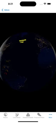
- Interactive Map with Tropical Cyclones, Live Clouds, and Earthquakes
- Sea Surface Temperatures for the past two months
- Graphical outlines of cloud formations that can turn into potential Tropical Storms
- 3D Earth with Live Clouds, Tropical Storms, and Earthquakes
- Tropical Storm and Weather Information, Summaries, Discussions, and Outlooks
8 World Radars for 12 different Locations around the Globe!
- Visible - Unenhanced visible imagery that transitions to IR2 overnight
- Shortwave - Channel 2 Shortwave Infrared imagery - Shortwave, sometimes considered "night visible"
- Water Vapor - IR Channel 3
- Aviation - Aviation color enhancement
- Dvorak - Used for tropical classifications with the Dvorak technique
- JSL - Used to bring out low level and high level clouds in tropical cyclones
- Funktop - Higlights intense areas of precipitation
- Rainbow - Rainbow enhancement curve, colorful enhancement
Innovative Features!
- 300+ World Radars: 18 Radar Locations around the globe with 17 Radars per Location
- Customizable Advanced Local Radar using NEXRAD technology (U.S. only)
- Projected Tropical Storm paths: Future tropical storm paths for the next five days
- Forecast and Hazards give you detailed forecasts for different periods of the day, and hazards that you should look out for (Tornado Watch, Flood Warning, High Tide, etc.) (U.S. only, Updated hourly)
- Innovative Lightning Intensity Radars
- Interactive Map with Tropical Cyclones, Live Clouds, and Earthquakes
- Sea Surface Temperatures for the past two months
- Graphical outlines of cloud formations that can turn into potential Tropical Storms
- 3D Earth with Live Clouds, Tropical Storms, and Earthquakes
- Tropical Storm and Weather Information, Summaries, Discussions, and Outlooks
8 World Radars for 12 different Locations around the Globe!
- Visible - Unenhanced visible imagery that transitions to IR2 overnight
- Shortwave - Channel 2 Shortwave Infrared imagery - Shortwave, sometimes considered "night visible"
- Water Vapor - IR Channel 3
- Aviation - Aviation color enhancement
- Dvorak - Used for tropical classifications with the Dvorak technique
- JSL - Used to bring out low level and high level clouds in tropical cyclones
- Funktop - Higlights intense areas of precipitation
- Rainbow - Rainbow enhancement curve, colorful enhancement
Rate the App
Add Comment & Review
User Reviews
Based on 0 reviews
No reviews added yet.
Comments will not be approved to be posted if they are SPAM, abusive, off-topic, use profanity, contain a personal attack, or promote hate of any kind.