GPS Map Camera Location & Time
1.0.3 by Deepsome Studio (0 Reviews) September 20, 2024
Latest Version
Version
1.0.3
1.0.3
Update
September 20, 2024
September 20, 2024
Developer
Deepsome Studio
Deepsome Studio
Categories
Travel & Local
Travel & Local
Platforms
Android
Android
Downloads
0
0
License
Free
Free
Package Name
com.gpscamera.mapgeotag.photolocation.timestamp
com.gpscamera.mapgeotag.photolocation.timestamp
Report
Report a Problem
Report a Problem
More About GPS Map Camera Location & Time
Discover the power of GPS Map Camera, your all-in-one GPS camera app for embedding GPS location (longitude and latitude), geolocation, timestamp, date, weather conditions, temperature, coordinates and more onto your photos and videos. Whether you need geotagged photos for work, travel, or personal memories, this GPS map camera is designed to ensure every shot is rich with essential data.
Key Features of GPS Map Camera:
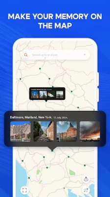
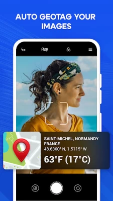
📍 Automatic GPS Location Stamping: With GPS Map Camera, every photo and video is automatically stamped with precise GPS location data, including longitude and latitude. This feature is ideal for creating accurate geotagged photos that display the exact location on map.
🌍 Detailed Geolocation Information: Not just coordinates—GPS Map Camera also adds comprehensive geolocation details like city and country names to your photos. This makes your geotagged photos more informative and ideal for documenting travels or fieldwork.
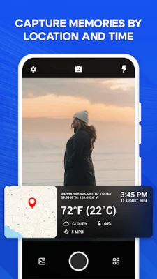
🕒 Accurate Timestamp and Date Stamping: Automatically tag a timestamp and date to each photo and video. The GPS camera ensures that your images have the precise date time stamp, capturing exactly when and where your moments happened.
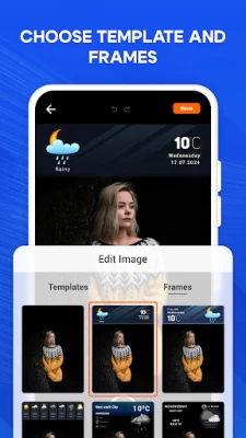
🌦 Weather and Temperature Stamping : Include real-time weather conditions and temperature in your photos with GPS Map Camera. Whether it's sunny, rainy, or snowy, your images will accurately tag and reflect the weather at the time of capture.
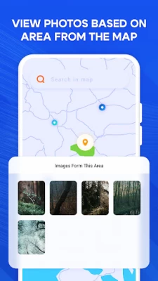
🗺 Location on Map Integration: Visualize where each photo was taken with the location on map feature. GPS Map Camera makes it easy to see the GPS location of all your geotagged photos on a map, perfect for retracing your steps.
🔧 Manual Geotagging and Timestamp Editing: Take full control with manual editing of the GPS location, geolocation, timestamp, and date. GPS Map Camera allows you to customize these details for perfect documentation.
📸 High-Quality Photos and Videos: Capture stunning, high-definition photos and videos with all your GPS, geolocation, timestamp, weather, and temperature data embedded automatically by GPS Map Camera.
🌐 Easy Sharing of Geotagged Photos: Share your geotagged photos and videos with friends, family, or on social media, complete with all the vital details like GPS location (longitude and latitude), geotag, timestamp, and weather.
Why Choose GPS Map Camera?
Whether you're a travel enthusiast, a professional photographer, a field researcher, or someone who loves documenting life’s adventures, GPS Map Camera is your go-to app. It provides everything you need to capture and preserve your memories with detailed GPS location, gps coordinates, geotagging, timestamp, weather, and temperature information.
GPS Map Camera ensures that your photos and videos are more than just images—they’re documented moments with all the crucial data like GPS location, geotagging, date time stamp, map coordinates, and weather conditions included. Download GPS Map Camera today and start creating geotagged photos that truly tell the whole story.
📍 Automatic GPS Location Stamping: With GPS Map Camera, every photo and video is automatically stamped with precise GPS location data, including longitude and latitude. This feature is ideal for creating accurate geotagged photos that display the exact location on map.
🌍 Detailed Geolocation Information: Not just coordinates—GPS Map Camera also adds comprehensive geolocation details like city and country names to your photos. This makes your geotagged photos more informative and ideal for documenting travels or fieldwork.
🕒 Accurate Timestamp and Date Stamping: Automatically tag a timestamp and date to each photo and video. The GPS camera ensures that your images have the precise date time stamp, capturing exactly when and where your moments happened.
🌦 Weather and Temperature Stamping : Include real-time weather conditions and temperature in your photos with GPS Map Camera. Whether it's sunny, rainy, or snowy, your images will accurately tag and reflect the weather at the time of capture.
🗺 Location on Map Integration: Visualize where each photo was taken with the location on map feature. GPS Map Camera makes it easy to see the GPS location of all your geotagged photos on a map, perfect for retracing your steps.
🔧 Manual Geotagging and Timestamp Editing: Take full control with manual editing of the GPS location, geolocation, timestamp, and date. GPS Map Camera allows you to customize these details for perfect documentation.
📸 High-Quality Photos and Videos: Capture stunning, high-definition photos and videos with all your GPS, geolocation, timestamp, weather, and temperature data embedded automatically by GPS Map Camera.
🌐 Easy Sharing of Geotagged Photos: Share your geotagged photos and videos with friends, family, or on social media, complete with all the vital details like GPS location (longitude and latitude), geotag, timestamp, and weather.
Why Choose GPS Map Camera?
Whether you're a travel enthusiast, a professional photographer, a field researcher, or someone who loves documenting life’s adventures, GPS Map Camera is your go-to app. It provides everything you need to capture and preserve your memories with detailed GPS location, gps coordinates, geotagging, timestamp, weather, and temperature information.
GPS Map Camera ensures that your photos and videos are more than just images—they’re documented moments with all the crucial data like GPS location, geotagging, date time stamp, map coordinates, and weather conditions included. Download GPS Map Camera today and start creating geotagged photos that truly tell the whole story.
Rate the App
Add Comment & Review
User Reviews
Based on 0 reviews
No reviews added yet.
Comments will not be approved to be posted if they are SPAM, abusive, off-topic, use profanity, contain a personal attack, or promote hate of any kind.