
GPS Location Info,Tactical Cam
1.0 by MI Division (0 Reviews) June 27, 2024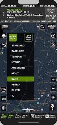
Latest Version
Version
1.0
1.0
Update
June 27, 2024
June 27, 2024
Developer
MI Division
MI Division
Categories
Maps & GPS
Maps & GPS
Platforms
Android
Android
Downloads
0
0
License
Free
Free
Package Name
com.midivision.savegpslocations
com.midivision.savegpslocations
Report
Report a Problem
Report a Problem
More About GPS Location Info,Tactical Cam
GPS Location Info Tactical is your ultimate companion for precise navigation and location tracking needs.
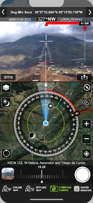
At its core, GPS Location Info Tactical provides you with real-time updates of your current location, displaying coordinates in various formats including Decimal Degrees, Degrees Minutes Seconds, UTM, and MGRS.
Offline Satellite Maps Never lose your way, even without an internet connection. GPS Location Info Tactical offers offline satellite maps, ensuring you always have access to detailed maps, no matter where your adventures take you.
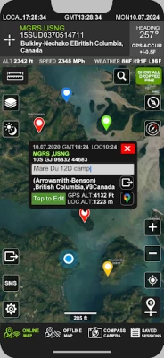
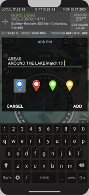
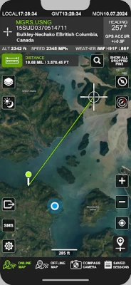
The app's intuitive interface offers a scrollable map, allowing you to pinpoint specific landmarks with ease using accurate crosshairs. Whether you're scouting for a hunting stand or planning a trek, you can save important locations by dropping pins for quick access later.
Measure any distance, route, directly on the map. Whether you're planning a hiking trail, assessing the perimeter of a hunting ground, or determining the distance between two points of interest, this tool provides invaluable assistance.
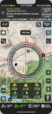
For enhanced navigation, GPS Location Info Tactical features a comprehensive mapping toolkit. Overlay compass maps onto the camera view to visualize your direction and precisely locate landmarks. Measure distances, routes, and areas directly on the map to plan your journey effectively.
Elevation data is readily available in both feet and meters, giving you a comprehensive understanding of your surroundings. Additionally, the app synchronizes with Greenwich Mean Time (Zulu time), ensuring precise timing for all your expeditions.
*Coordinates of the map's center are shown in next formats:
- Dec Degs (DD.dddddd˚)
- Dec Degs Micro (DD.dddddd "N, S, E, W")
- Dec Mins (DDMM.mmmm)
- Deg Min Secs (DD°MM'SS.sss")
- Dec Mins Secs (DDMMSS.sss")
- UTM (Universal Transverse Mercator)
- MGRS (Military Grid Reference System)
Offline Satellite Maps Never lose your way, even without an internet connection. GPS Location Info Tactical offers offline satellite maps, ensuring you always have access to detailed maps, no matter where your adventures take you.
The app's intuitive interface offers a scrollable map, allowing you to pinpoint specific landmarks with ease using accurate crosshairs. Whether you're scouting for a hunting stand or planning a trek, you can save important locations by dropping pins for quick access later.
Measure any distance, route, directly on the map. Whether you're planning a hiking trail, assessing the perimeter of a hunting ground, or determining the distance between two points of interest, this tool provides invaluable assistance.
For enhanced navigation, GPS Location Info Tactical features a comprehensive mapping toolkit. Overlay compass maps onto the camera view to visualize your direction and precisely locate landmarks. Measure distances, routes, and areas directly on the map to plan your journey effectively.
Elevation data is readily available in both feet and meters, giving you a comprehensive understanding of your surroundings. Additionally, the app synchronizes with Greenwich Mean Time (Zulu time), ensuring precise timing for all your expeditions.
*Coordinates of the map's center are shown in next formats:
- Dec Degs (DD.dddddd˚)
- Dec Degs Micro (DD.dddddd "N, S, E, W")
- Dec Mins (DDMM.mmmm)
- Deg Min Secs (DD°MM'SS.sss")
- Dec Mins Secs (DDMMSS.sss")
- UTM (Universal Transverse Mercator)
- MGRS (Military Grid Reference System)
Rate the App
Add Comment & Review
User Reviews
Based on 0 reviews
No reviews added yet.
Comments will not be approved to be posted if they are SPAM, abusive, off-topic, use profanity, contain a personal attack, or promote hate of any kind.