Elevation Tracker
1.2.0 by Altitude at a glance (0 Reviews) July 04, 2024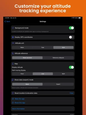
Latest Version
Version
1.2.0
1.2.0
Update
July 04, 2024
July 04, 2024
Developer
Altitude at a glance
Altitude at a glance
Categories
Maps & GPS
Maps & GPS
Platforms
iOS
iOS
File Size
4 MB
4 MB
Downloads
0
0
License
Free
Free
Report
Report a Problem
Report a Problem
More About Elevation Tracker
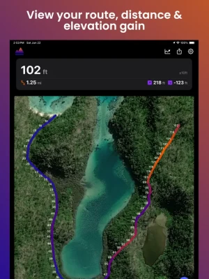
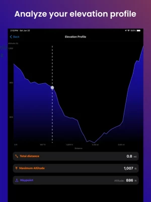
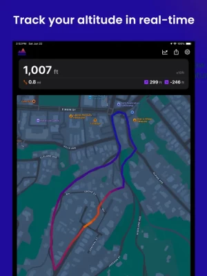
Elevation Tracker (AltiTrack) allows you to track your altitude in real-time and visualize the elevation along your route.Altitude measurements are obtained from your phone's internal GPS sensor, offering optimal accuracy outdoors and in open areas.
AltiTrack features include:
- Live altitude display
- Altitude tracking on a map in satellite, hybrid, or normal mode
- Choice of measurement units between meters and feet
- Selection of altitude reference
- Real-time display of GPS coordinates
- Ability to share & export your location and altitude data
- Customization of your route display according to your preferences
The app works perfectly without an internet connection.
Download AltiTrack today to keep control of your altitude and route!
Rate the App
Add Comment & Review
User Reviews
Based on 0 reviews
No reviews added yet.
Comments will not be approved to be posted if they are SPAM, abusive, off-topic, use profanity, contain a personal attack, or promote hate of any kind.