

Buoy Map
2.1 by Joel Lisenby (0 Reviews) September 14, 2024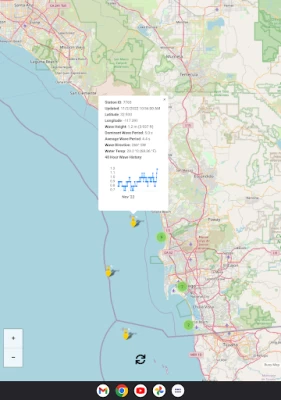
Latest Version
Version
2.1
2.1
Update
September 14, 2024
September 14, 2024
Developer
Joel Lisenby
Joel Lisenby
Categories
Sports
Sports
Platforms
Android
Android
Downloads
0
0
License
Free
Free
Package Name
com.ridelegend.ridelegend
com.ridelegend.ridelegend
Report
Report a Problem
Report a Problem
More About Buoy Map
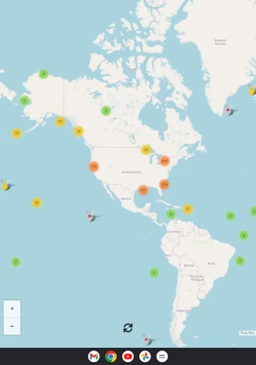
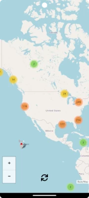
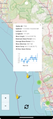
A world map with live buoy data provided by the United States National Oceanographic and Atmospheric Administration (NOAA). Updated every 30 minutes with the latest data, including last 48-hour wave height graphs.
Buoy data includes (each buoy has a different set of instruments so not all sensors apply to every buoy):
* Wind Direction
* Wind Speed
* Wind Gust Speed
* Wave Height
* Wave Height 48 Hour History (Graph)
* Dominant Wave Period
* Average Wave Period
* Wave Direction
* Air Pressure
* Air Pressure Trend
* Air Temperature
* Water Temperature
I plan to add new features frequently and I hope that you find this app helpful. Suggestions and constructive criticism is welcome.
Enjoy!
Rate the App
Add Comment & Review
User Reviews
Based on 0 reviews
No reviews added yet.
Comments will not be approved to be posted if they are SPAM, abusive, off-topic, use profanity, contain a personal attack, or promote hate of any kind.