

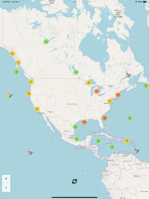
Buoy Map
1.4 by Map of ocean/lake buoy data (0 Reviews) January 05, 2024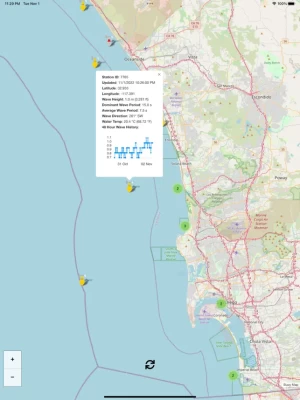
Latest Version
Version
1.4
1.4
Update
January 05, 2024
January 05, 2024
Developer
Map of ocean/lake buoy data
Map of ocean/lake buoy data
Categories
Weather
Weather
Platforms
iOS
iOS
File Size
7.9 MB
7.9 MB
Downloads
0
0
License
$1.99
$1.99
Report
Report a Problem
Report a Problem
More About Buoy Map
Buoy data includes (each buoy has a different set of instruments so not all sensors apply to every buoy):* Graph of 48hr wave height* Wind Direction* Wind Speed* Wind Gust Speed* Wave Height* Dominant Wave Period* Average Wave Period* Wave Direction* Air Pressure* Air Pressure Trend* Air Temperature* Water Temperature
I plan to add new features frequently and I hope that you find this app helpful. Suggestions and constructive criticism is welcome.
Enjoy!
Open Source Credits: this Buoy Map app uses OpenStreetMap.org as a map provider and Leaflet.js as the map and icon engine.
Enjoy!
Open Source Credits: this Buoy Map app uses OpenStreetMap.org as a map provider and Leaflet.js as the map and icon engine.
Rate the App
Add Comment & Review
User Reviews
Based on 0 reviews
No reviews added yet.
Comments will not be approved to be posted if they are SPAM, abusive, off-topic, use profanity, contain a personal attack, or promote hate of any kind.