AvareX
0.0.14 by Apps For Aviators (0 Reviews) June 21, 2024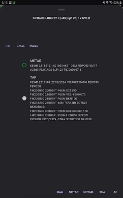
Latest Version
Version
0.0.14
0.0.14
Update
June 21, 2024
June 21, 2024
Developer
Apps For Aviators
Apps For Aviators
Categories
Maps & GPS
Maps & GPS
Platforms
Android
Android
Downloads
0
0
License
Free
Free
Package Name
com.apps4av.avaremp
com.apps4av.avaremp
Report
Report a Problem
Report a Problem
More About AvareX
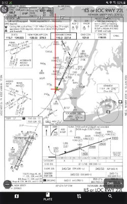
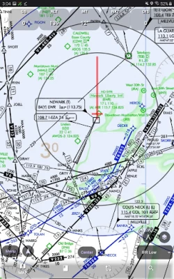
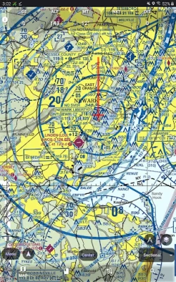
AvareX is designed for pilots and contains Geo-referenced FAA Aeronautical Charts, IFR (High and Low), VFR (Sectional and TAC), Flyway, helicopter, instrument approach plates, and Chart Supplements for the United States and its territories only. For charts outside of the Unites States AvareX relies on "OSM" or Open Street Maps. AvareX supports ADS-B in data from any Wi-FI GDL-90 device (Eg Stratux) and will display traffic, weather, and other ADS-B received data.
AvareX is free to use with no additional costs and is a pending replacement for the original Avare application. AvareX is community supported and funded through user donations.
AvareX is currently is a Beta stage
AvareX is currently is a Beta stage
Rate the App
Add Comment & Review
User Reviews
Based on 0 reviews
No reviews added yet.
Comments will not be approved to be posted if they are SPAM, abusive, off-topic, use profanity, contain a personal attack, or promote hate of any kind.