
AtAltitude
1.4.4 by Track altitude,location,hpa (0 Reviews) March 04, 2024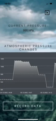

Latest Version
Version
1.4.4
1.4.4
Update
March 04, 2024
March 04, 2024
Developer
Track altitude,location,hpa
Track altitude,location,hpa
Categories
Weather
Weather
Platforms
iOS
iOS
File Size
37.1 MB
37.1 MB
Downloads
0
0
License
Free
Free
Report
Report a Problem
Report a Problem
More About AtAltitude
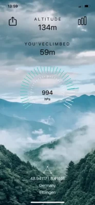
Track your altitude, coordinates, and meters in the mountains with AtAltitude. No internet connection required, only GPS data.
AtAltitude is a reliable and accurate offline altimeter that uses GPS data to determine your altitude, coordinates and location, barometric pressure and display it as a graph. Find out how far you have climbed the mountain. Get accurate altitude readings, use the built-in compass and get a weather forecast for the mountainous area.
Rate the App
Add Comment & Review
User Reviews
Based on 0 reviews
No reviews added yet.
Comments will not be approved to be posted if they are SPAM, abusive, off-topic, use profanity, contain a personal attack, or promote hate of any kind.